
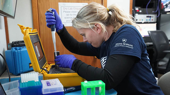
Haley DeHart, a genomics research scientist at APL, collects samples of environmental DNA that she can use to determine what animal species have recently been in an area.
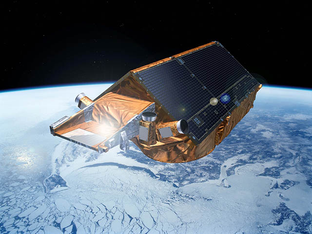
The European Space Agency’s CryoSat-2 mission, launched in 2010, provides data used to determine changes in ice sheet and sea ice thickness but lacks the power of a radar sounder.
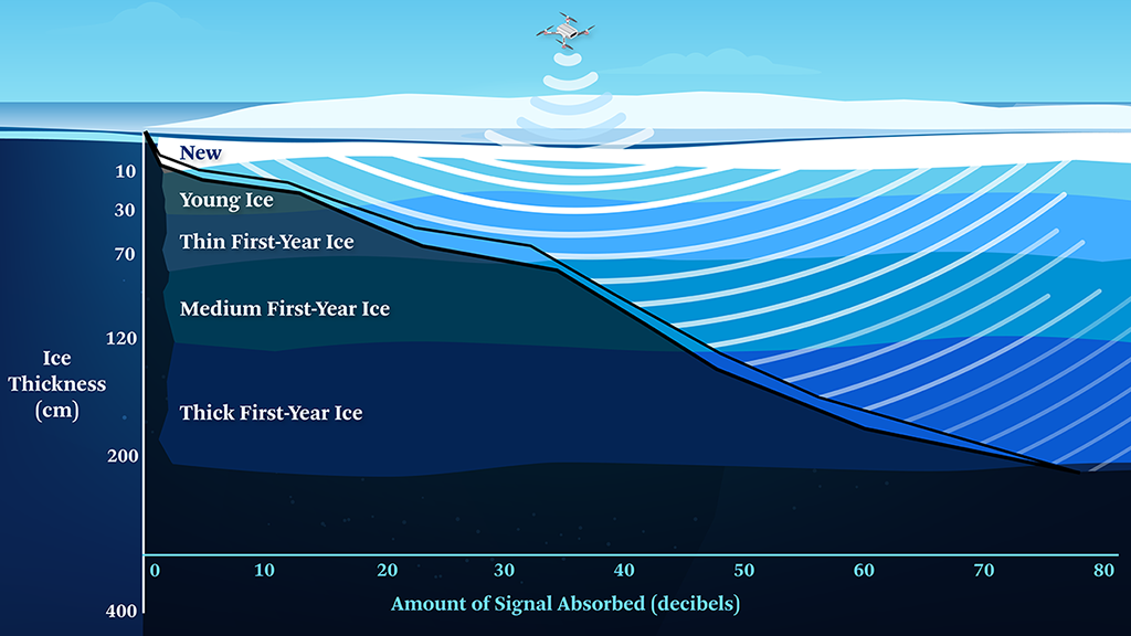
The expected depth and absorption of radar signals emitted by Walrus in new, young and first-year Arctic sea ice
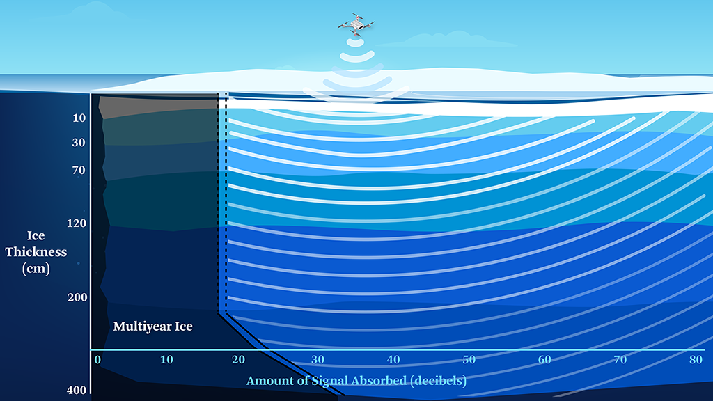
The expected depth and absorption of radar signals emitted by Walrus in multiyear Arctic sea ice
Newswise — Off the southeastern tip of Greenland in mid-June, Hayley DeHart, a genomics and marine scientist at APL, disembarked Lindblad Expedition’s National Geographic Endurance — a 407-foot (124-meter) ice-cutting cruise ship — and stepped into a small Zodiac inflatable motorboat.
She carried only a few items with her: a bucket, a rope and some sampling equipment for her experiments. She settled in with the ship captain and other researchers aboard and then motored off into the frigid, untouched waters.
Click here for Interactive Features
Environmental DNA, or eDNA, originates from the bits of skin, tissue and waste that animals slough off as they move through their environment.
The study of eDNA is a lot like underwater forensics. Even dilute samples can pick up the faint signatures from a species that was (or maybe still is) in the surrounding area. Because of that, eDNA is increasingly viewed as a powerful biological monitoring tool, revealing everything from ecosystem biodiversity to the presence of protected or endangered species such as whales.
In December 2022, for example, scientists reported uncovering ancient environmental genetic material more than 2 million years old from sediments near the northern tip of Greenland. The DNA revealed that the region’s now barren surface once held a rich boreal forest ecosystem. Poplar and birch trees covered the landscape while populations of hares, caribou and even mastodons fed among their trunks — all just 600 miles (965 kilometers) from the North Pole.
Since 2021, when the United States, European Union and eight other countries ratified a 16-year moratorium on commercial fishing in the Arctic, researchers like DeHart have had a chance to better understand the Arctic ecosystem and ecology. They can track its response to the warming climate and survey its biological populations before more human activity occurs in these regions.
DeHart’s work is part of an ongoing effort at APL to set up permanent eDNA analysis platforms capable of supporting long-lasting research capabilities while at sea. These approaches incorporate everything for sample collection, molecular processing, and genomic data analysis. These environmental characterization platforms leverage the APL-developed software package called Basestack. Developed in 2019, Basestack is an easy to distribute and user-friendly platform that allows researchers and public health workers around the world to perform rapid and real-time analyses of sequencing data. Genetic analysis that was previously hard to set up and unwieldy to use, requiring powerful hardware and high-speed internet to operate, can now run locally on off-the-shelf laptops through an intuitive interface.
With such capabilities now available in the most remote parts of the world like the Arctic, researchers can collect data from the poles at the same time of year, creating datasets that are consistent over time. “Those measurements are incredibly important for understanding the climate and how it’s changing,” said David Porter, a longtime oceanographer and chief scientist at APL. “That knowledge may not directly affect our generation, but if we start collecting data now, we’ll create a foundation for future studies that will help generations to come.”
But while eDNA and genetic sequencing tools can help track how the climate is changing and the Arctic organismal community is responding, they don’t address the one issue that is affecting everything and everyone right now: Arctic sea ice.
Mary Keller, a remote sensing scientist in APL’s Space Exploration Sector, has more than 40 years of experience in microwave remote sensing. She developed algorithms to characterize sea ice during the summer melt while at the U.S. Naval Research Laboratory in Washington, D.C., and monitored ice year-round in both the Arctic and Antarctic for the National Ice Center in Maryland. She says the big unknown about the Arctic right now is how thick the sea ice is, an attribute critical to the climate in general.
“The older the sea ice and [the] thicker it is, the more it acts as Earth’s refrigerator,” Keller explained.
The thick, bright-white ice reflecting sunlight back into space keeps the planet cool. But as ice begins to melt, more of the dark, heat-absorbing surface of the ocean is exposed, creating a feedback loop that accelerates the melting process. The result is the release of thick and dangerous ice chunks into the paths of ships, infrastructure and coastlines.
For years, scientists have made efforts to measure sea ice thickness.
Both the European Space Agency’s CryoSat-2 (a delay-Doppler radar altimeter) and NASA’s ICESat and ICESat-2 laser altimeters infer sea ice thickness by measuring the height of the ice above sea level. As with ice cubes and icebergs, generally, one-tenth of the ice sits above water surface. The rest remains below.
But none of these altimeters, Keller said, has the power of a method called radar sounding.
Like synthetic aperture radar (SAR) and laser altimetry, radar sounding works by sending rapid pulses of electromagnetic waves from antennas and measuring how long it takes the pulses to reflect back. But the method uses low microwave frequencies that can penetrate deep into a substance, including miles of ice. The result is a cross-sectional image of the ice with direct measurements of its thickness, volume and strength.
In 2018, Keller with her colleague Josh Cahill and a team of APL scientists and engineers proposed building such a sounder for sea ice. It would be part of an ice-monitoring infrastructure, with a sounder on a satellite working in conjunction with others on an airplane or uncrewed aerial vehicles to capture more localized, higher-resolution measurements closer to the ground. They could even provide data for forecasting where ice is headed. Once interfaced with SAR data from other satellites, they could provide complete coverage over a desired region of the Arctic. They called the project Walrus.
The idea of using radar sounding wasn’t new.
In fact, sounders have been used to explore features on the Moon and the polar ice caps on Mars. NASA’s Europa Clipper mission will even use one to peer beneath the ice on Jupiter’s ice-covered moon Europa, which is suspected to have a global (and potentially life-bearing) ocean below the ice.
The main problem with using it to study sea ice on Earth, Keller said, is the salt. Salt rapidly absorbs microwave signals. Even at optimum frequencies for peering into sea ice, which Keller and her team calculated is around 600-900 megahertz, you can see through just 7 feet (2 meters) of saline ice. By comparison, NASA’s Pathfinder Advanced Radar Ice Sounder that APL built and operated in the mid-2000s could see through nearly 2 miles (3 kilometers) of freshwater glacial ice on top of Greenland.
Given enough time (meaning years), the salt will flush out, leaving multiyear ice that is essentially frozen freshwater like that in glaciers. But as the climate changes, more and more ice in the Arctic will be first-year ice, so there’s a lot of salt to deal with.
At the ideal frequencies, the team figured they still could see to the bottom of very thick first-year ice with 12-inch (30-centimeter) resolution. “With that, we could actually get ice thickness that correlates to the different ice types,” Keller said.
They have yet to get the sounder built, though, because various efforts to get the program off the ground have stalled.
Without an ice sounder, Keller said, we risk not being able to fully understand or predict how the ice or Earth’s climate will change. It’s also dangerous for ships — if you don’t know where the thick ice is and where it’s going, you can’t confidently say where there’s a safe passage.
“I think there’s a great deal we need to continue to do,” Keller said. “We can’t just stop and say the problem is solved because the Arctic is changing, and even as we speak, we don’t know exactly how far the change is going to go and how it’s going to evolve.”
MEDIA CONTACT
Register for reporter access to contact detailsArticle Multimedia
Credit: Lindblad Expeditions-National Geographic
Caption: Haley DeHart, a genomics research scientist at APL, collects samples of environmental DNA that she can use to determine what animal species have recently been in an area.
Credit: European Space Agency
Caption: The European Space Agency’s CryoSat-2 mission, launched in 2010, provides data used to determine changes in ice sheet and sea ice thickness but lacks the power of a radar sounder.
Credit:
Caption: The expected depth and absorption of radar signals emitted by Walrus in new, young and first-year Arctic sea ice
Credit:
Caption: The expected depth and absorption of radar signals emitted by Walrus in multiyear Arctic sea ice