Newswise — Russian hydrophysicists elaborated a method for research of salinity of the Azon Sea with the help of data from the remote sensing. Scientists matched satellite images of water surface with field measurements and discovered that they can prognose salinity of water with an accuracy to 95%. The obtained magnitudes of salinity from 1 to 18 % turned out to be realistic with the consideration of average values (10-12%), obtained during fieldworks. The new method will enable to reduce the price of works concerning estimation of salinity in direct process, to fill the gaps in hydro chemical research of the Azov Sea in the previous years, and also to widen views about processes of circulation of water masses, that influence the development of biological resources and inshore infrastructure of the Azov Sea. Results of the research are published in International Journal of Remote Sensing.
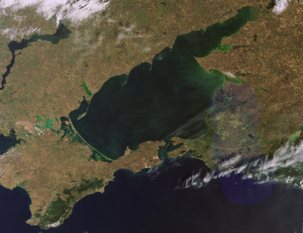
The Azov Sea (Azov) – is a continental sea in the eastern Europe. This is the shallowest sea in the world with average depth of less than 7 meters. Its chemical characteristics, for example, salinity, are very changeable, especially in the inshore part of the sea. It is connected with the fact that rivers flowing into the Azov bring sometimes more, sometimes less water depending on the season. Besides this, waters of the Azov Sea are mixed with waters of the Black Sea and lake Sivash, and also are subjected to pollution near coasts. It also influences instable dynamics of sea salinity.
Scientists from Marine Hydrophysical Institute (Sevastopol) found the way to define the level of salinity of the Azov Sea distantly. Taking into account that field researches are expensive and conducted irregularly, satellite observations can become a beneficial alternative. Authors used free data from the base “OceanColor” in order to get images of surface of the Azov Sea of high resolution. However, these images themselves, that present water spaces of different colors, tell nothing about salinity of water. Moreover, measurement of salinity, in contrast to changes in temperature of water, are principally impossible only using satellite observations.
In order to interpret satellite photos of sea surface researchers used data of full-scale examination of water, obtained during expeditions from 1913 to 2018. Classical definition of salinity is carried with the help of chemical method after scientists selected water and brought it to the laboratory. Comparison of real and satellite information enabled to make regressive dependances between obtained figures in order to use in future only satellite images for estimating of water salinity of the Azov Sea. Mainly it is concerned those parts of the reservoir and that time, when field researches hadn’t been conducted in the Azov.
“Our researches showed that chosen mathematical model for measurement of salinity of the Azov Sea enables to prognose with a probability of 95%. This method gives realistic figures of salinity in diapason from 1 to 18 % with average field figures 10-12%. Truly speaking, it concerns only summer and spring, because there are enough researches from a ship during expeditions. However in future we are planning to do the same works for autumn and winter seasons”,- tells one of authors of the work Tatyana Shulga, Senior Researcher of department of hydrophysics of shelf of Marine Hydrophysical Institute RAS.
The conducted researches open an opportunity for further estimation of circulation of water masses of the Azov Sea. This process directly depends on changes of water density, that are defined by temperature and salinity. If earlier with the help of satellites it was possible to study only thermal regime of the Azov, now distant sounding enables to estimate also salinity of the sea. From the practical point of view a new method and its usage will help scientists to understand influence of circulation of water masses on biological resources, ecology and inshore infrastructure of Azov Sea better. Besides this in future thanks to new opportunities scientists can reconstruct hydrologic parameters of the Azov Sea in protosatellite epoch.
The material has been prepared with the financial support of Ministry of Education of Russia within the federal project «Popularization of science and technology».