As it captivated people around the world, the January eruption of the Hunga Tonga-Hunga Ha’apai volcano gave scientists a once-in-a-lifetime chance to study how the atmosphere works, unlocking keys to better predict the weather and changing climate.
High Mountain Asia, the planet’s most extensive icy systems outside the polar regions, have the world’s largest undeveloped hydropower potential and are seeing numerous dams and reservoirs under construction or planning. However, climate change is destabilising the landscapes and threatening numerous hydropower projects according to a new study led by researchers from the National University of Singapore (NUS).
Researchers from Washington University in St. Louis received a grant from the National Science Foundation to determine the thermal and compositional structure of Antarctica using seismic, gravity and topography data and petrological modeling.
While wildfires over recent years have raged across much of the western United States and pose significant hazards to wildlife and local populations, wildfires have been a long-standing part of Earth’s systems without the influence of humans for hundreds of millions of years.
USC scientists have found evidence that the Earth’s inner core oscillates, contradicting previously accepted models that suggested it consistently rotates at a faster rate than the planet’s surface.
While much of public attention on Yellowstone focuses on its potential to produce large supereruptions, the hazards that are much more likely to occur are smaller, violent hydrothermal explosions.
The emergence of a mysterious area in the South Atlantic where the geomagnetic field strength is decreasing rapidly, has led to speculation that Earth is heading towards a magnetic polarity reversal.
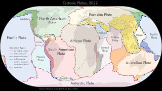
New models that show how the continents were assembled are providing fresh insights into the history of the Earth and will help provide a better understanding of natural hazards like earthquakes and volcanoes.
In the fall of 2017, geology professor Patricia Gregg and her team had just set up a new volcanic forecasting modeling program on the Blue Waters and iForge supercomputers.
Scientists have come up with a new classification scheme for mountain belts that uses just a single number to describe whether the elevation of the mountain belt is controlled mainly by weathering and erosion or by properties of the Earth’s crust, i.e., the lithospheric strength: the “Beaumont number” (Bm).
Eden, a geoscience technology development company co-founded by Massachusetts Institute of Technology/Woods Hole Oceanographic Institution Joint Program student Paris Smalls, will receive $3.8 million in federal funding from the U.S. Department of Energy Advanced Research Projects Agency-Energy (ARPA-E).
An ancient bout of global warming 56 million years ago that acidified oceans and wiped-out marine life had a milder effect in the Gulf of Mexico, where life was sheltered by the basin’s unique geology – according to research by the University of Texas Institute for Geophysics (UTIG).
Today, the Salton Sea is an eerie place. Its mirror-like surface belies the toxic stew within. Fish skeletons line its shores and the ruins of a once thriving vacation playground is a reminder of better days.
In many streams and rivers, water moves between the open channel and the adjacent groundwater, enabling reactions that can remove or transform carbon, contaminants, and nutrients. Researchers developed a new modeling strategy to represent these effects in watershed-scale models. The new model addresses current models’ limited ability to simulate how carbon, nutrients, and contaminants move and transform in river corridors and allows for a new generation of research on river networks.
Magmatic volatile contents, such as water, are abundant in volcanic arc melts and influence magma evolution, dynamics of volcanic eruptions and the formation of ore deposits.
This increased amount of water has broad implications for understanding how Earth’s lower crust forms, how magma erupts through the crust, and how economically important mineral ore deposits form, according to a new paper led by authors from the Woods Hole Oceanographic Institution (WHOI), “High water content of arc magmas recorded in cumulates from subduction zone lower crust,” published in Nature Geoscience.
Urban construction, especially the ongoing large-scale expansion and utilization of underground space, has resulted in massive excavated soil and rock (ESR) from buildings and subways.
Billions of years ago, a series of volcanic eruptions broke loose on the moon, blanketing hundreds of thousands of square miles of the orb’s surface in hot lava.
In a study published in the journal Nature Communications, Andrea Mundl-Petermeier and Sebastian Viehmann of the Department of Lithospheric Research at the University of Vienna have demonstrated that a new geochemical archive - 182Tungsten in banded iron formations - can be used to simultaneously trace both the evolution of the Earth's mantle and continents throughout Earth’s history. This offers new opportunities to better understand the Precambrian Earth in the future.
The massive Jan. 15 eruption of the undersea Hunga Tonga-Hunga Ha’apai volcano in the South Pacific Ocean was a once-in-a-century event that allowed an international group of 76 scientists using multiple forms of technology to crowdsource their data in ways never before possible.
New research by an international team from 17 countries including Lawrence Livermore National Laboratory (LLNL) scientist Keehoon Kim demonstrates that based on atmospheric pressure waves recorded by global barometers, the Hunga explosion was comparable in size to that of the 1883 Krakatoa eruption.
A Florida State University faculty member has been named a 2022 Division Outstanding Early Career Scientist by the European Geosciences Union (EGU). Richard Bono, an assistant professor in the Department of Earth, Ocean and Atmospheric Science, received the award in the EGU’s Earth magnetism and rock physics division.
Ice shelves are floating extensions of glaciers. If Greenland’s second largest ice shelf breaks up, it may not recover unless Earth’s future climate cools considerably. This is the result of a new study, published in Nature Communications.
A new study finds evidence of surprisingly rapid upward movement of earth’s crust on the island of Taiwan. Over roughly half a million years, the Coastal Range of east Taiwan was rising at a rate of 9 to 14 millimeters per year, the research shows.
The National Science Foundation (NSF) has awarded Cornell College W.H. Norton Professor of Geology Rhawn Denniston a $199,785 grant to study the use of stalagmites as records of prehistoric fire activity in the Australian tropics.
Using satellite imagery to study the effects of a 2019 landslide on the Amalia Glacier in Patagonia, a University of Minnesota-led research team found the landslide helped stabilize the glacier and caused it to grow by about 1,000 meters over the last three years.
A URI-led expedition to the Puerto Rico Trench took what researchers believe to be the deepest water core samples ever taken in the Atlantic. They’re also the deepest water cores taken anywhere in the oceans since 1962.
The lake level of the Dead Sea is currently dropping by more than one metre every year - mainly because of the heavy water consumption in the catchment area.
In a new article published in the Journal of Biogeography, SUNY Geneseo geographer Associate Professor Stephen Tulowiecki and four undergraduate researchers examined the influence of Native American land use on the composition of historic forests in the Northeastern United States. The team found that Native American settlements and land use had a lesser effect on the distribution of tree species across the region when compared to climate and soil conditions.
The 2016 Kumamoto earthquakes shocked inhabitants of the western island of Kyushu, causing hundreds of casualties and serious damage to vital infrastructure.
The 12 August 2021 South Sandwich Island earthquake had a surprise hidden within its complex rupture sequence: a slow, shallow magnitude 8.16 subevent that was “invisible” to researchers at first glance.
A geologic formation near Aix-en-Provence, France, is famed as one of the world’s chief treasure troves of fossil species from the Cenozoic Era. Since the late 1700s, scientists there have been unearthing amazingly well-preserved fossilized plants and animals.
Los Alamos National Laboratory and the U.S. Geological Survey have entered a partnership to produce advanced computer models to predict the behavior of wildfires and prescribed fires. Models will help fire, land and emergency managers plan for, respond to and study the effects of fire on natural landscapes and in the wildland-urban interface.
When a large ice sheet begins to melt, global-mean sea level rises, but local sea level near the ice sheet may in fact drop. In American Journal of Physics, a researcher illustrates this effect through a series of calculations, beginning with a simple, analytically tractable model and progressing through more sophisticated mathematical estimations of ice distributions and gravitation of displaced seawater mass. The paper includes numerical results for sea level change resulting from a 1,000-gigatonne loss of ice, with parameter values appropriate to the Greenland and Antarctic ice sheets.
In disaster mitigation planning for future large earthquakes, seismic ground motion predictions are a crucial part of early warning systems and seismic hazard mapping.
Rather than digging to identify unmarked mass grave sites or evidence to locate missing persons, new technologies are helping law enforcement agents, forensic scientists and historians uncover attempts to hide victims.
A group of Finnish, Swedish, and Norwegian geologists provide critical new evidence for the timing of volcanic activity in the Karoo province, the largest of the Jurassic magma systems. The remnants of the province are widespread in southern Africa and Antarctica.
Deserts may seem lifeless and inert, but they are very much alive. Sand dunes, in particular, grow and move – and according to a decades long research project, they also breathe humid air.
Satellite data has confirmed that an ice shelf about the size of Manhattan has completely collapsed in East Antarctica within days of record high temperatures. The Conger ice shelf, which had an approximate surface area of 1,200 square km, collapsed around March 15, scientists confirmed today.
The Greenland Ice Sheet is the second largest ice body in the world, and it has the potential to contribute significantly to global sea-level rise in a warming global climate.
Earthquakes are famously impossible to predict, and have been the cause of some of the most devastating events in human history. But could we learn more about these natural disasters by tracking them backwards through time?
Planetary scientist Christopher Edwards and his team will use renewed NASA funding for Mars Science Lab Curiosity Rover project to continue exploring the rock record on the Red Planet.
Earthquakes themselves affect the movement of Earth's tectonic plates, which in turn could impact on future earthquakes, according to new research from the University of Copenhagen.